1. Introduction
Groundwater represents a continental archive that stores the multiple interactions among the different environmental components. This function can be used in environmental studies to obtain information about environmental changes, climate data comparison, and the paleo-climate (Zhang et al. 2017). Despite their vital importance, these resources are facing severe deterioration in many countries all over the world relative to the impacts of increasing exploitation and climate variability. The continuous decrease in the resilience of these systems, known as the slow component of the hydrological cycle with long-term responses (Russo, Lall 2017), generally leads to irreversible ecological impacts, frequently resulting in serious disasters and important economic losses (Swezey 1996; Edmunds et al. 2003; OSS 2003; Molden et al. 2010; Hamed et al. 2014a-b; Zhang et al. 2017).
Given the crucial role of groundwater in maintaining ecological balance, especially in hot and dry areas, the sustainability of groundwater resources in response to the continuous socio-economic development and intensifying climate variability has gained traction in recent years (GIEC 2007; Waiyaki et al. 2012). However, water conservation is an extremely complex process, difficult to evaluate and manage, mainly regarding deep multi-layered aquifers. It requires a quantitative and qualitative assessment of potential productivity, degradation issues, and management plans given institutional, political, engineering, technical, and financial drivers based on a sound analysis of ecological consequences requirements, economic growth needs, and social stabilization.
The evaluation of the efficiency of the adopted management actions involves, consequently, all the factors and conditions that may influence the performance of the water-dependent system during the entire exploitation process, from the real water requirements to the calculated water productivity ratio and the measured gains (Barker et al. 2003). This evaluation is generally associated with high uncertainty given the heterogeneous proprieties of the deep aquifers, which have hampered the comprehensive understanding of the hydrodynamic behavior evolution and the accurate identification of contamination sources and pollutant transport flows (Ayers, Westcot 1985; Edmunds et al. 2003; Kumar 2012; Konar et al. 2012; Russo, Lall 2017).
Numerous studies have reviewed the increasing risks from groundwater overdevelopment, focusing on the environmental risks associated with expanding groundwater exploitation, namely groundwater quality deterioration, associated ecological impacts, environmental degradation, and natural resource pollution (Hamed et al. 2014a-b; Mokadem et al. 2016; Zhang et al. 2017; Besser, Hamed 2019). Based on the results, prediction of the responses of these fragile resources to the emerging issues is related to natural conditions (background geochemical and climate) and anthropogenic perturbations (land use, exploitation, contamination), and the feasible remediation measures are constrained by several challenges. Once these aquifers are contaminated, remediation seems to be a challenging task given the cumulative hidden impacts that may induce long-term changes, depending on the inherent aquifer proprieties and the specific contaminant characteristics.
In southwestern Tunisia, as a large part of the Middle East and North Africa areas (MENA), the overexploitation of deep groundwater has attracted considerable attention (Guendouz et al. 1997; Edmunds et al. 2003; Kamel 2013; Hamed et al. 2014a-b; Hamed 2015; Mokadem et al. 2016; Besser et al. 2017, 2018, 2019, 2021; Besser, Hamed 2019; Dhaouadi et al. 2020, 2021). These works have highlighted various pieces of evidence of groundwater degradation leading to the gradual intensity of several socio-economic implications. The study area of the Tozeur and Kebili regions, characterized by harsh climatic conditions with less than 100 mm of precipitation (INM 2019), solely relies on groundwater resources to meet the increasing demands, of which more than 82% is devoted to the agricultural sector (CRDA 2020). The hydrogeological system of the region is represented by the multi-layered SASS (Système Aquifère du Sahara Septentrional) aquifer system, consisting of two principal aquifers according to the lithologic variation, geological age, the distribution of aquifers and aquitards and hydrodynamic conditions: the Complex Terminal (CT) (Salinity ranging from 1.7 to 5.3 g/L) located in the Cretaceous and the Early tertiary porous deposits of the Continental Intercalaire (CI) in the thick Mesozoic-Early Tertiary sediments (temperatures from 35 to 78°C and salinity from 2.5 to 5.8 g/L) (Agoun 2005; Ben Brahim et al. 2012; Kamel 2013; Mokadem et al. 2016; Besser et al. 2017). The intensifying exploitation of these semi-confined to confined reservoirs, despite the low renewability potential under the present-day conditions (lack of surface water, scarce and irregular precipitations), induces a series of environmental issues that seem to be progressively irreversible (Kamel 2013; Hamed et al. 2014a-b; Besser, Hamed 2019, 2021).
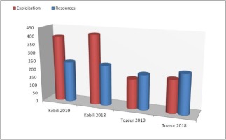
Correspondingly, various actions of remediation have been adopted during the last two decades, such as international and national projects (PDES, APIOS, CES), sensibilization frameworks, periodic training programs for farmers via conferences, numerous formation sessions completed by field surveys with the association of local and regional institutions (CRDA, CRRAO, IRA), investment reinforcement, financial and administrative support with eco-benefits for water and soil savers, national valorization of the individual innovative alternative of environmental conservation, and several pilot stations for new water-saving techniques (Dhaouadi et al. 2021). However, the overexploitation of these natural resources has continuously increased from 393.3 Mm3 in 2010 to 418.64 Mm3 in 2019 for only 242.2 Mm3 of available resources in the Kebili region (from 162.38% to 172.84% of the exploitation ratio in 9 years) and from 176.5 Mm3 to 197.23 Mm3 for the same period in Tozeur area, where the available resources are of 208.4 Mm3 (an increase of 1.29% of the exploitation ratio per year). This has resulted in more severe environmental issues frequently measured and (or) observed during the last years (Hamed et al. 2014a-b; Besser et al. 2019, 2021).
Besides their ecological impacts, the inefficiency and inadequacy of environmental protection measures, taken until the present, threaten the economic income and the food security of the residents depending exclusively on agriculture for their livelihood. Thus, and regarding the complex open and partially known proprieties of these reservoirs; considering the frequent water stress repercussions and the lack of continuous large-scale data, a re-evaluation of the management strategies aiming for the rational exploitation of these low renewable resources and an accurate assessment of the ecological risks as well as the value of the rehabilitation measures is required based on several environmental, pedagogical, hydrogeological and petroleum studies conducted in the study area, coupled with field surveys.
In this context, this paper presents a careful review of the historical data in southern Tunisia about the amplitude of the emerging ecological concern resulting from the inadequate management of groundwater resources within the largest aquifer system of the Continental (CI) Intercalaire aquifer. It aims (1) to discuss the gradual potential and measured risks associated with groundwater exploitation and quality degradation, (2) to outline the principal political, socio-economic, and institutional drivers of efficient monitoring systems to early predict further degradation, and (3) to present a synthesis of the relevant factors and processes governing fruitful exploitation and optimal productivity concerning the Eco-Eco dimensions, opening expanding research areas.
2. Groundwater vulnerability
Groundwater resources exhibit different vulnerability degrees depending on several natural and anthropogenic factors. Natural groundwater vulnerability relies on the recharge conditions and the impacts of the climate variability (Randall, Mulla 2001; Foster et al. 2002; Gurdak et al. 2007). Thus, the deep confined hydrogeological systems are considered particularly vulnerable to different forms of degradation and depletion regarding their low renewability and the insufficient amount of freshwater dilution, even if re-charge flows are available (Wu, Hunkeler 2013; Freitas et al. 2015). The evaluation of this vulnerability, despite the various estimation methods and the increasing accuracy of the performed analyses, is ranking high, along with great uncertainties mainly related to the anisotropy of aquifer properties (intrinsic vulnerability), the great spatio-temporal variability of the most influencing factors, and the causal relationship between the natural system characteristics and the evolutionary external environment (risks, challenges, land use, land management, climatic oscillations, human exploitation) (Rickwood, Carr 2009; Hamed 2015; Besser, Hamed 2019; Burri et al. 2019).
In the study area, based on the review of the collected monitoring data and previously published research, the vulnerability of groundwater resources was evaluated via the usable amount or the exploitation ratio, which may not provide sufficiently accurate information about the evolution of the equilibrium balance of the natural ecosystem. Generally, the usable amount of groundwater represents the amount of groundwater that can be continuously exploited without any environmental issues. It defines the limits of the re-charge-discharge ratio concerning the aptitude of the natural system to regain balance. However, for most countries globally, the question is no longer about the equilibrium status but about the limits of reversible-irreversible effects which cannot accurately be evaluated as the resilience of the natural system is inadequately qualitatively described and indirectly quantitatively assessed via indirect effects generally observed a posteriori. Additionally, given the multiple influencing factors for multi-layered, and the huge extent of the CI aquifer system understanding the hydrodynamic and geochemical transition of the system represents a huge participatory task that needs the agglomeration of large data sets of different water-controlling factors and water-dependent sectors to gain information about the intrinsic evolution of the system in response to natural and anthropogenic stimulation. This assessment is afflicted with additive constraints when the investigated resources are semi-confined transboundary low renewable resources under present-day conditions and with a slow response, such as the continental Intercalaire aquifer.
Historically, the abstraction from the CI aquifer has begun in the late 1970s (OSS 2003); prior to this time, the surface manifestations of underground water have played a fundamental role in human settlements and social development (Foggaras, and Mkayel systems). This exploitation is variable at a regional scale (Algeria 6.1 Bm3, Tunisia 0.72 Bm3, and Libya 0.95 Bm3; Fig. 1), depending upon accessibility (Edmunds et al. 1997, 2003; OSS 2003). Such variability may be explained by the different productive horizons in exploitation (geological structure, structural configuration of the multi-layered aquifer of CI) (Baba Ould 2005; OSS 2014; Petersen et al. 2014); despite this regional variability in the exploitation ratio from 78% to 216%, overall, the CI resources in the study area are in a state of overexploitation (CRDA 2017; Besser et al. 2019).
Besides the differences in exploitation among the three countries, the vulnerability of the hydrogeological system shows a local variability from 180% in the Tozeur area to more than 270% in the Kebili region, highlighting different degrees of resilience and, consequently, various corresponding risks. The degree of vulnerability of the aquifer, in this case, is evaluated according to various features, namely the presence of systematic control, exploitation rate, recharge conditions, climate impacts, water-dependent economy evolution, institutional and reglementary conditions. Nevertheless, for SW Tunisia, the lack of rigorous aquifer protection policies has led to progressively observed incidents related to the regional head decline and a permanent quality degradation. These effects are generally difficult to remediate considering the huge reservoir of the aquifer, the long residence times of CI water, and the physical inaccessibility to these deep confined resources.
The agglomeration of the results highlights the high level of vulnerability for decades, whereas the exploitation is continuously resulting in various environmental challenges discussed in the following sections.
3. Exploitation concerns about water table lowering
Frequent water shortage has resulted in the sharp growth of the exploitation of groundwater for different usages, consequently exceeding the carrying capacity of groundwater, especially in hot-dry areas with low annual rainfall, such as SW Tunisia, where the percentage of the humid period does not exceed 10% (Ferchichi 1996). This continuous abstraction to meet the agricultural demands (70% of the total regional demand for water) in southern Tunisia causes declining groundwater levels and aquifer replenishment (FAO 2020). Under natural conditions, the cycling period of deep groundwater is more than a thousand million years (Edmunds et al. 2003); the deep groundwater resources that have been exploited are made mainly of paleo waters, which were recharged thousands or tens of thousands of years ago.
The water table evolution of the CI aquifer indicates that the groundwater level fell sharply, and the depression cones have been developed quickly due to continuous overexploitation (Edmunds et al. 1997; Ben Brahim et al. 2012; Hamed et al. 2014a). The water withdrawal amount shows a remarkable spatial distribution that exhibits a good correlation with the availability of complimentary water resources and the expansion of agricultural lands. The average water table decrease is 2 to 3 m/yr (OSS 2014), reaching 10 m locally in some regions of the Kebili field, where the situation becomes more critical with two or three water wells implemented in less than 100 m, such as in the case of Esteftimi (Besser et al. 2017). The cumulative impacts of these neighboring boreholes induced large depression cones and modified the local flow directions (Besser et al. 2019). According to previous studies, the hydrodynamic behavior of the CI groundwater system, regarding the complex lithologic proprieties of the multi-layered system and the multi-directional tectonic features, has become difficult to predict as the preferential pathways can be modified in response to the continuous exploitation, leading to a series of environmental problems such as inversion drainage from the Chotts aquifer downward to the deep reservoirs as well as for the shallow new-formed aquifer beneath the oasis agro-systems (Omar et al. 2019).
Based on the guidelines and the threshold of international water legislation, the evolution of the CI water table defines seriously overexploited areas with a restricted amount of overexploitation for those requiring urgent remediation and areas with increasing attention for those needing continuous examination This classification in SW Tunisia considers the quasi total area of Tozeur and Kebili as a zone protected from further exploitation and the creation of new water wells. Unfortunately, the number of private water wells has exceeded 10,000 in 2020 (CRDA 2020). Given the growing use of solar power systems, the abstraction is no longer determined either with measures or estimations. Thus, these efforts should be completed with severe governmental and institutional control.
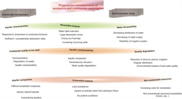
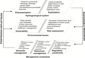
Groundwater withdrawal will impact all water-dependent ecosystems (requiring surface expression or water availability) with different geomorphologic features and flow mechanisms (Foster, Perry 2010; Eamus et al. 2015). In the studied area, the frequent inaccessibility to irrigation water has led to the expansion of private illegal water wells which, in turn, have induced uncontrolled exploitation adversely affected land productivity. In fact, the important quantities of delivered irrigation water for cultivated crops are largely above the recommended requirements leading to progressive waterlogging of poor water quality unsuitable for agriculture purposes. This quality, which represents a huge challenge, often attracts less consideration until the potential repercussions define irreversible impacts (Fig. 2).
The major issue constraining rehabilitation plans is related to the variable progressive responses of groundwater resources to increasing exploitation and continuous depletion on the anisotropic distribution of physical proprieties of the hydrogeological system, aquifer dimensions, and boundary conditions (Konikow, Leake 2014; Besser et al. 2019), requiring a continental-scale mapping framework and expert knowledge to complete a shared task via a participative interdisciplinary approach.
4. Concerns about quality deterioration
Groundwater abstraction and pumping can alter natural flows and modify the small-scale water balance (hydrogeological cycle), increasing groundwater desiccation (Custodio 2005), defined by the process of groundwater rebound upon mining and pumping cessation, with likely implications for groundwater quality (Henton 1981). Pumping and continuous abstraction from deep aquifers have undoubtedly various impacts on groundwater recharge and flow movements and increase system vulnerability to incurable effects. The spatial distribution of this vulnerability mainly depends on the intrinsic aquifer characteristics, reservoir geometry, anthropogenic development, and field features (Khan et al. 2016; Russo, Lall 2017). In the case of fossil groundwater, such as the CI aquifer system, this evaluation includes the assessment of water chemistry evolution, concerning the paleoclimatic oscillations and the exploitation conditions. For the transboundary systems, such as the SASS multi-layered aquifer, local geological and tectonic features are to be considered, as well as the sedimentary-structural proprieties of the large-scale basins, which define the physical characterization of the aquifer, control the hydrodynamic behavior of groundwater, and, consequently, influence the different processes governing the distribution of water composition. However, the heterogeneity of the natural environment, coupled with the partially known aquifer characterization at a large basin, can make a straightforward characterization of many systems nearly impossible (Hakoun et al. 2017). This situation defines a growing challenge for remediation and rehabilitation efforts, despite the multiple studies and management plans related to the complexity of the system and the adequacy and accuracy of the collected data concerning water quality degradation, which remains generally elusive (Famiglietti 2014).
Table 1 shows a summary of the overall assessment of the measured and (or) observed quality problems of the CI aquifer. Increasing salinization and alkalization issues have been reported for more than 82% of the total analyzed points. The major challenge for the continuous use of these waters is mainly related to the unclear trend of water quality and chemical composition evolution. Additionally, recent works have indicated that an important percentage of groundwater resources in the study area is enriched with trace elements (Besser, Hamed 2019).
Table 1.
Improvements in water productivity.
The changes in groundwater quality are caused by the dual impacts of humans and the intrinsic factors of the hydraulic system, namely mixing and hydraulic continuity (Sheng et al. 2020). A significant decline in groundwater level changes the stress state of the groundwater system and accelerates vertical and horizontal groundwater migration, possibly resulting in the migration of poor-quality groundwaters from deeper reservoirs and (or) from the Chotts brackish aquifer. Additionally, significant correlations have been found among soil degradation, desertification, vegetation ecosystem destruction, and the excessive development and use of groundwater. Besser et al. (2021) indicated that during the last 20 years, the quality of CI water was not suitable for irrigation purposes, which has resulted in fertility losses. These findings are confirmed by field investigations done by Dhaouadi et al. (2021) and justified by the GIS-based models developed by Besser and Hamed (2021). The distribution of the most sensitive areas for potential land degradation is consistent with the spatial evolution of groundwater abstraction (Sepehr et al. 2007; Maroufpoor et al. 2018). Adequate soil moisture is the basic condition required for healthy vegetation growth without physiological stresses or oasis shrinking (Peng et al. 2014; Sheng et al. 2020; Besser et al. 2017). Hence, the long-term decline in groundwater levels has further led to a reduction in crop yield quality, as well as the degradation of wind break and sand fixation oases and forests, among other serious ecological problems in the region (Zammouri et al. 2007; Besser et al. 2017, 2021).
5. Concerns about land subsidence
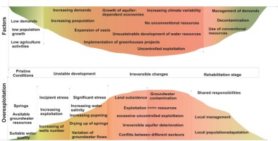
Land subsidence caused by the over exploitation of groundwater has become an increasingly serious challenge in many arid and semi-arid regions (Sheng et al. 2020). Previous studies (Hamed et al. 2014a-b; Cao et al. 2016; Zhang et al. 2017) have demonstrated that there is an important causality link between land subsidence and groundwater level decrease, especially in the hot dry areas of China and the MENA regions. In these water-deficient areas, extensive groundwater pumping induces a progressive compaction of sediments after water subtracting from porous horizons, leading to land subsidence (Han et al. 2014; Sheng et al. 2020). The subsequent land use changes and the cumulative impacts of anthropogenic activities via gradual alteration of the equilibrium of the hydrogeological system (decompression, geometry) induce natural subsidence, which is enhanced in human-induced sensitive areas. The rehabilitation of this form of degradation is generally difficult, time-consuming, and expensive as it requires an accurate evolution of the subsidence rate and the exploitation amount for determining the required pressure to regain pristine conditions in view of the subterranean architecture (Figs. 3 and 4).
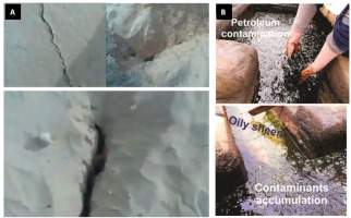
Fig. 4.
Observed degradation issues: A. Land subsidence (Hamed et al. 2014a); B. Petroleum contamination (Besser, Hamed 2019).
According to a previous study in the same area, the sediments of a fluvio-deltaic complex, such as the mega sequence of the Lower Cretaceous, are susceptible to high compressibility and significant natural subsoil compaction and aeration (Syvitski et al. 2009). These properties define the high intrinsic vulnerability to the various effects of human activities, namely excessive pumping and the continuous exploitation of deep aquifers (Kamel 2013; Hamed 2015; Zhang et al. 2017).
Land subsidence is defined by the ultimate consequence resulting from the agglomeration of the cumulative impacts exceeding the recommended limits for natural equilibrium regeneration. It is a sluggish process with slow progressive evolution in response to several time-dependent factors and processes mainly related to gradual land use changes (Hamed et al. 2014a-b). Overexploitation induces a progressive over-pressure dissipation from clay-rich sediments, which start to compact according to a time-dependent secondary consolidation. This slow evolution highlights the importance of the resilience of natural systems to consecutive uncontrolled stimulations up to the ultimate tolerance limits (Fig. 3)
Correspondingly, the overexploitation of groundwater in the study area was amplified by an extensive area of land subsidence in 2013 at the Douz region (Kebili-SW Tunisia), related to a local piezometric drop of about 2.5 m (Hamed et al. 2014a). This subsidence indicated that the exploitation has exceeded the regenerative capacity of the aquifer and that the porosity caused by the continuous abstraction from the CI aquifer resulted in an unrecoverable compaction of the permeable horizons, which cannot support the charge of the overlain sediments, consequently inducing a fall of the upper sedimentary column (Hamed et al. 2014a-b).
6. Concerns about water contamination
Aquifer intrinsic vulnerability to different contamination types and sources is amplified by the increasing risks for groundwater quality deterioration relative to the anthropogenic environment. The complex links between the natural dynamics of the successive processes of the hydrogeological cycle can be significantly modified by man-induced physical alterations, water resources exploitation, and industrial or chemical pollution. Deep aquifers are generally considered, regarding their depth and limited outcrop at the recharge areas, less prone to these types of contamination (Essefi et al. 2013; Besser, Hamed 2019). These properties, which may ensure a relative protection of these reservoirs, represent, at the same time, a real challenge for remediation as once the aquifer is contaminated, it seems difficult to reliably evaluate the amplitude of contamination, the diffusion of pollution, the pollutant inflow into the aquifer, and the groundwater quality deterioration (Conant et al. 2004; Chapman, Parker 2005; Freitas et al. 2015; Moeck et al. 2017; Burri et al. 2019).
Despite the various types of investigation and the various methods commonly used to examine a likely incident, only a fraction of the flow and some transport pathways can be identified (Göppert, Goldscheider 2008; Robert et al. 2012). The effects of anthropogenic practices (land development, natural resources exploitation) on groundwater in terms of pollutant diffusion, multi-point sources, inflow movement, and transport modeling are various, revealing increasing risks from reversible impacts to incurable effects. These likely consequences are discussed in a number of scientific papers to underscore the myriad of issues that can arise when anthropogenic controls are present on top of natural controls (Gonçalves et al. 2007; Hakoun et al. 2017; Burri et al. 2019) (Fig. 3).
The query about the magnitude of the released concentrations of the pollutants into the aquifers and the potential recovery of the background safe contents, as well as the time required to reset the pristine conditions, is complex. These issues require detailed studies based on modeling the response of the aquifers, developed through accurate analysis of the different scenarios of system evolution. The uncertainty, related to the unpredictable response of the aquifer due to the anisotropic characteristics of the subterranean basin, is constraining the management of deep aquifer resources (Edmunds et al. 2003; Baba Ould 2005; Kamel 2013; Besser, Hamed 2021). Thus, to adjust certain physical and chemical properties of these deep reservoirs, a hierarchical list of the contaminants is required, containing the description of the sites altered by multiple pollutants and the areas requiring rapid clean-up actions.
In the study area, despite the serious degradation measured and observed for CI waters, the exploitation has been continuous, largely threatening these critical resources. Hamed (2015) and Besser and Hamed (2021) have indicated a progressively emerging issue related to the contamination of the CI aquifer by continuous oil/gas flow, which may be considered the ultimate impact of groundwater mismanagement (Besser et al. 2017; Besser, Hamed 2019). The contamination was observed at the canals distributing hot waters as well as along the atmospheric cooling systems, forming a unique hydrocarbon seepage mixed with groundwater resources in the MENA region. This contamination is confirmed by the results of the analyses via the GC-MS technique, which indicate the presence of different pollutants such as octacosane, 1,2-benzenedicarboxylic acid, ditridecyl ester, hexadecanoic acid, trimethylsilyl ester, cyclooctasiloxane, and hexadecamethyl. The concentrations of asphalt exceeded 4 g/L in CI water, and the total petroleum amount reached 16 mg/kg for agricultural lands in the contaminated zone (Besser et al. 2019; Besser, Hamed 2019).
Different hypotheses have been put forward to evaluate the migration pathways by which petroleum enters aquifers, based on the tectonic evolution of the region, the local structural and geological features of the region, and the hydrodynamic and hydrogeological properties of the water-bearing system. The paleo-geological and tectonic history of the region is characterized by numerous active tectonic and sedimentary phases. Faults and fractures created by the successive tectonic processes and hydraulically induced fractures related to lateral and vertical changes of the aquifer geometry and lithology may act as permeable conduits controlling pathways of fluid migration. These preferential pathways have been investigated in several geophysical studies (Hlaiem 1999; Said et al. 2011; Zouaghi et al. 2011; Soua 2014), confirming the presence of numerous local-scale faults in the contaminated field that may play a major role in the distribution of pressure and upward-moving fluids. These multidimensional faults create complex subsurface drainage systems, ensuring hydraulic continuity between the different water-bearing strata. These conduits ensure the migration of petroleum under huge pressure from deeper reservoirs (Mejri et al. 2006; Akrout et al. 2012), especially in the context of the great charge difference in comparison with the upper, overexploited aquifer.
Irrespective of the multiple ways by which the pollutants enter the aquifers, the continuous contamination and the diffusion of pollutant flows are consistent with the increasing exploitation of the aquifer (Figs. 3 and 4). This pollution is irreversible considering the partially known properties of the aquifer and the unstable properties of petroleum products.
7. Synthesis
This literature review of the likely consequences of natural resources exploitation highlights the strong causal links between anthroposophical drivers and the processes of land degradation. This explicit evaluation is of paramount importance to provide insights into the political and institutional constraints for appropriate natural resources conservation. This study, conducted in southern Tunisia, outlines the necessity of a quantitative multi-criteria index of risk evaluation of groundwater exploitation that summarizes the partially known features of the open and the complex subterranean system. It proves that the responses of the groundwater circulation system to the external environmental perturbations range from relative disequilibrium strengths to various incurable changes with progressive intensity and severity, requiring an environmental sensitivity baseline study.
This review is urgently required for the CI aquifer in southern Tunisia, a huge groundwater system of crucial ecological and economic importance currently facing various degradation issues. The following question remains: What are the actions and measures to provide for the next step to at least conserve the current disequilibrium of the balanced ecological vs. socio economic values of these resources?
In the last decades, different approaches have been adopted in southern Tunisia to mitigate the impacts of the continuous exploitation of CI groundwater resources. More than 10 national and international projects have been developed, different techniques of irrigation have been used, along with renewable energy system implementation, the creation of new irrigated parcels, experiences and pilot stations, and the development of a wastewater station. However, the environmental issues have grown with the continuous agricultural expansion. This unbalance highlights the low effectiveness of the chosen approach and the lack of rigorous control to attend the optimal adhesion to the planned strategies. Such inadequate management results in more serious issues.
Currently, as the situation has reached a critical status that requires effective and urgent actions, the remediation should be defined by a careful design of hierarchical actions comprising projects, programs, plans, policies, and individual initiatives ensuring full integration or relevant biophysical, economic, social, and political considerations; this would facilitate wider scenarios of protection and exploitation (Table 1).
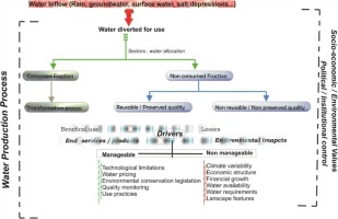
Sivapalan et al. (2012) and Di Baldassarre et al. (2013) indicated that the ambiguous aspects of the political strategies on the economic efficiency of water resources use define a new research field related to sociohydrology raison, the self-organizing managing efforts along with collective actions. In the study area, despite the crucial importance of groundwater for social and economic development, socio-ecological studies coupled with the findings of socio-environmental modeling, socio-hydrology, human-natural system modeling, and behavioral economics (Camerer et al. 2004; Filatova et al. 2015; Liu et al. 2016), have not yet been applied (Fig. 5).
7.1. Economic efficiency vs. environmental security
Agricultural water productivity as a broad concept is expressed in terms of the water benefit output by the water volume input (Bossio et al. 2010). This encompasses biophysical, environmental, social, and economic aspects for the nexus exploitation-production-sustainability. The assessment of this productivity requires the review of the involved values at different scales (plant field, farm, irrigation network, basin, agro-economic zone) and for different stakeholders (farmers, system managers, policy makers) (Amede et al. 2009; Descheemaeker et al. 2009; Gebreselassie et al. 2009; Haileslassie et al. 2009; Peden et al. 2009; Bossio et al. 2010). The concept of water productivity further includes a variety of options of water use related to scales of irrigated fields, systems of agricultural development, cultural practices, and water access security (Maxwell, Wiebe 1999).
Correspondingly, to increase water productivity in the presence of important water allocations, the three important terms, namely waster use efficiency (water productivity), water scarcity (water availability, cycle resilience, storage), and water requirements, should be identified regarding the water-dependent sector and the corresponding economic value before embarking on assessing the global economic equilibrium. The premise of sustainable water management relies on the flexible adaptation of these global notions at small-scale proprieties of the ecosystem, referring to a number of physical, chemical, and biological changes in natural resources and landscapes. The key factor governing the success or failure of these actions refers to obtaining reliable information about the obvious quantifiable effects and reducing the ambiguity concerning the insidious impacts frequently detected a posteriori (Barker et al. 2003; Bossio et al. 2010; Liu et al. 2016).
Regarding agro-based countries such as Tunisia, where water exploitation increases with high and low water productivity, several cautions should be attributed to differentiate between the highest short-term crop water productivity and the optimal water productivity, taking into account the ratio of the consumed water to the lost fraction, the requirements of the irrigated crops, the harvest index, and the runoff released into the environment.
The irrigation technique is one of the most important factors conditioning water productivity and water use efficiency. In southwestern Tunisia, agricultural performance has gained crucial importance in management plans (Hatfield et al. 2001; Stocking 2003; Bossio et al. 2010). The comparative analysis of the efficiency of irrigation with respect to water productivity in monetary terms indicates that the micro-techniques increase economic productivity while optimizing water use according to the requirements of the cultivated crops (Dhaouadi et al. 2020, 2021). These techniques have, in turn, crucial importance for sustaining land conservation and soil fertility; they inhibit the development of different forms of land degradation (CEC, salinization, acidification, nutrient depletion). However, different conditions may constrain the appropriate adoption of these techniques in the study area due to the lack of adequate large datasets for rainfall, evapotranspiration, and soil properties (Oweis, Hachum 2003).
The economic analysis in southern Tunisia is also constrained by the non-continuous monitoring data concerning livestock, non-conventional water resources, and soil properties modification. This intermittent data collection and the non-reliable information from participants inhibit a clear assessment of a number of profitability indices, namely benefit-cost ratio, non-productive value, and internal rate of return, which are of crucial importance for the evaluation of water use efficiency and, consequently, water conservation plans (Figs. 5, 6). The lack of efficient communication among social, scientific, and institutional committees needs to be considered.
7.2. Rehabilitation measures
Despite the various papers discussing the evolution of groundwater chemistry in response to natural factors and anthropogenic perturbations in southern Tunisia, such discussion is generally restricted to the first two categories explained in Table 2. Rehabilitation measures, however, require a dynamically comprehensive analysis to provide a scientific decision-making basis for social and economic development (Barker et al. 2003; Oweis, Hachum 2003).
Table 2.
Environmental conservation approach.
The successful management depends on a participatory approach in which farmers play the pivotal role to regain confidence and to create a reliable database, the baseline step for further management efforts (Gigar-Reverdin, Gihad 1991; Sileshi et al. 2003; McGregor 2004a). Additionally, institutional organizations re-organize accessibility to water and soil resources to obtain a clear image of the degradation drivers at local scale. These governmental participants should encourage the investment into degraded land and contaminated sites with more financial, technical, and administrative support. The participatory methods emphasize training and building capacity for voluntary engagement in conservation efforts within social and political drivers. The valorization of the indigenous knowledge of farmers and their individual initiative represents, in addition, a relevant alternative to enhance water resources conservation based on the cultural heritage of farmers. Pricing irrigation water based on water efficiency, irrigation water transfer; runoff water harvesting systems, the importance of the cultivated types, and the adoption of water-soil saving techniques (Table 2) further constitutes an important alternative to mitigate the emerging issues of water degradation.
The renewable energy systems can, in turn, be used to purify the treated wastewater to reduce the costs. Solar and wind energy can also be applied for the managed aquifer recharge, especially in the contaminated field, to restore the pressure of the groundwater in the deeper aquifer and inhibit the migration of petroleum from Jurassic and Paleozoic reservoirs. Obviously, the first step to inhibit further diffusion of the contamination is increasing the groundwater recharge to presume the equilibrium conditions. Some geologic storage structures in the region of interest for underground reservoir construction may reduce depression cones and ground subsidence. This may resolve the problem of groundwater pollution diffusion by regulating groundwater pressure. The implementation of inter-basin water transfer structures represents an effective method for achieving groundwater recharge, alleviating water scarcity during water shortage periods in spring and summer (Figs. 6 and 7).
Pretty et al. (2006), Noble et al. (2006), and Bossio et al. (2010) have indicated that the rehabilitation of degraded sites using resource conserving techniques may achieve sustainable outcomes, especially for smallholder agricultural systems, with increasing yields and lower investments (Figs. 6 and 7). Thus, a detailed characterization of the study area should be conducted at local scale to implement a flexible management plan.
Additionally, the used irrigation technique and irrigation scheduling constraint the effectiveness of the water resources management. Thus, an evaluation of the requirements of the cultivated crops is essential to redistribute the quantity with the lowest loss of irrigation water to evaporation (“more cop less drop”). Financial and engineering support for farmers to implement new localized irrigation techniques is required.
All these alternatives should be completed with rigorous control and the continuous training of landowners (Fig. 5 and Table 2). The policy of local-level intervention represents the backbone of resource conserving and rehabilitation programs. The re-organization of institutional and political dimensions and values is of paramount importance for the long-term environmental support adoption of a green-revolution type package of complementary inputs in economies with low agriculture. The involvement of non-agricultural organisms, farmers, and water-use associations (farm advisors) derives a community-based management to ensure long-term land resources sustainability. This participatory approach strengthens the links among farmers, advisors, researchers, economists, and policy makers.

